Epistemes of Cartography
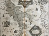
Maps are privileged media for representing knowledge. The cartographic dispositif not only makes it possible to organize existing knowledge but often generates new knowledge by spatializing data and illustrating connections. As instruments of knowledge, maps are not representations of reality but rather designs for understanding the world. This research area examines both the functioning of the cartographic device in concrete historical case studies and its role in the history of knowledge as such. The digitally annotated maps of Naples have proved their value in this regard and are receiving evermore uptake in the academic community. New additions are the particularly early map by the military architect Carlo Theti from 1560, and the critically annotated legends of the maps of Alessandro Baratta and the Duca di Noja. The panorama of Naples by Jan van Stinemolen (1582), which flouts convention by showing the city from the countryside and thus staging its embedding in nature, has been studied in particular detail by a group of scholars leading to a joint publication. Generally speaking, the main interest of this research area is to question the relationship between maps and other media that visualize space. This visual discourse was explored in greater depth at a conference that focussed on transmediality. The contributions have just been published under the title The Mediality of Mapping. Transmedial Approaches to Space and Cartographic Imagination, ed. by Tommaso Morawski and Tanja Michalsky, Rome 2024.


